Log in
All resources
Create a design
636 Free Images of Old Maps Of Amsterdam
history
historical
maps in the stadsarchief amsterdam
bibliothèque nationale de france
maps by willem and johannes blaeu
maps in the rijksmuseum amsterdam
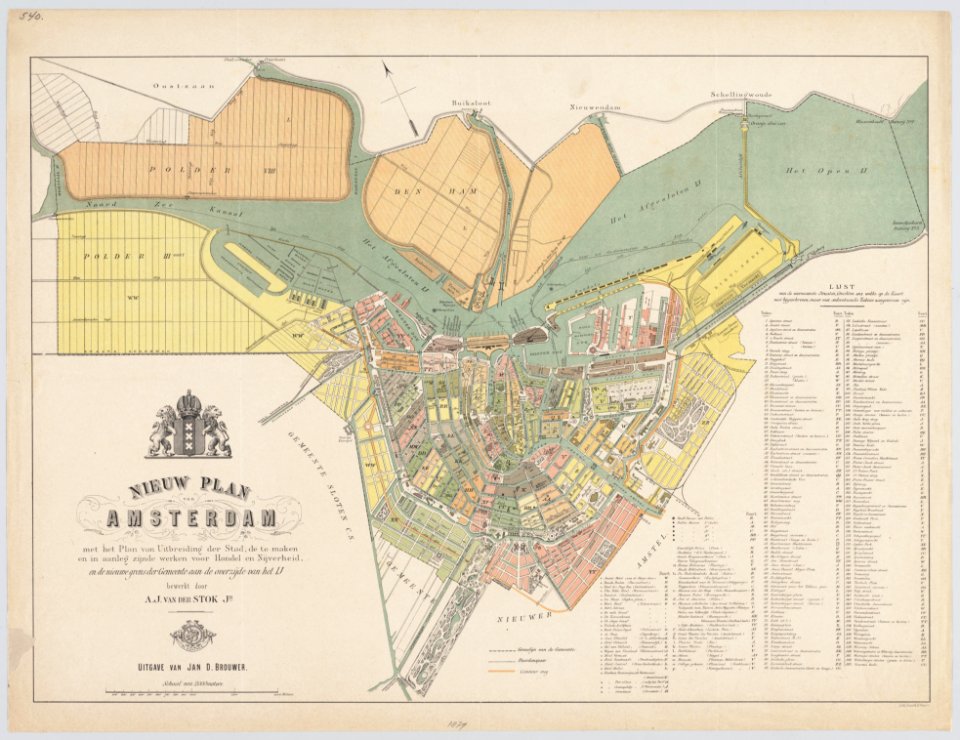
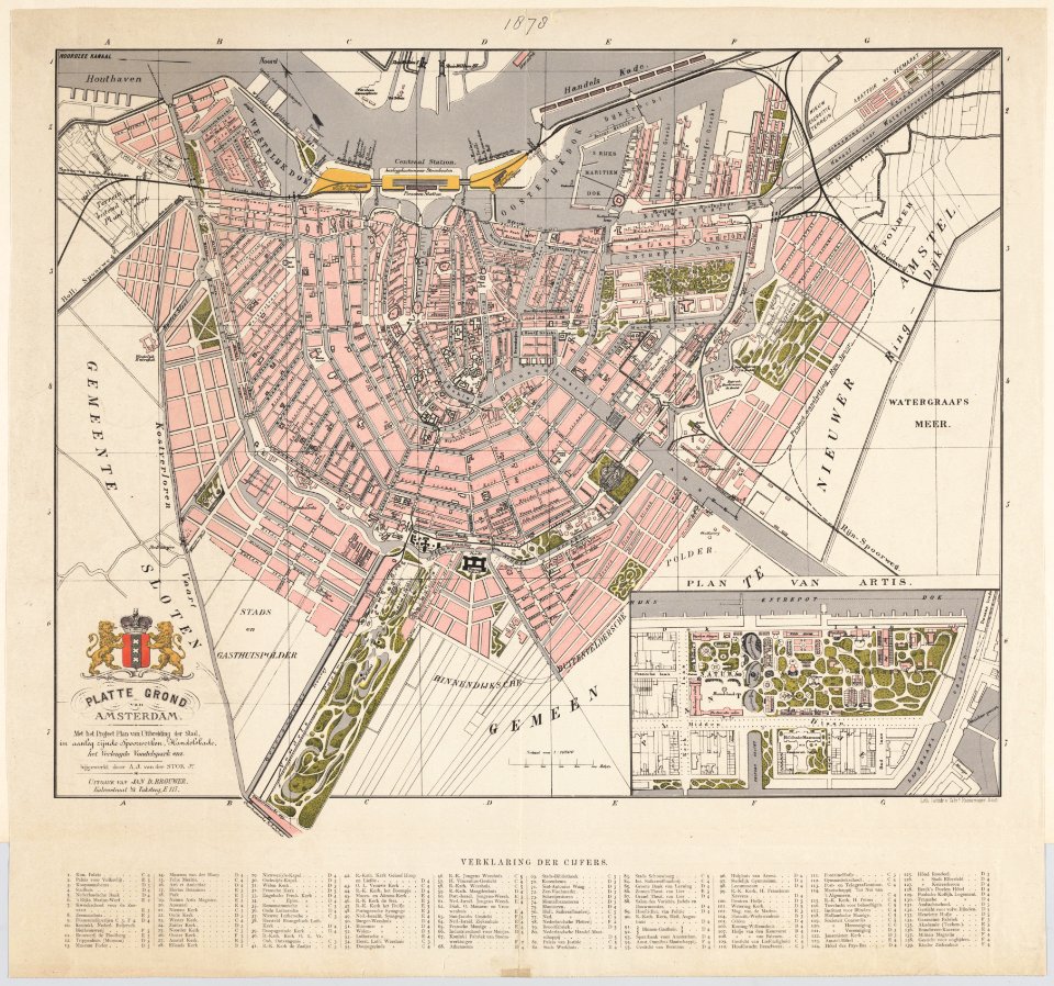
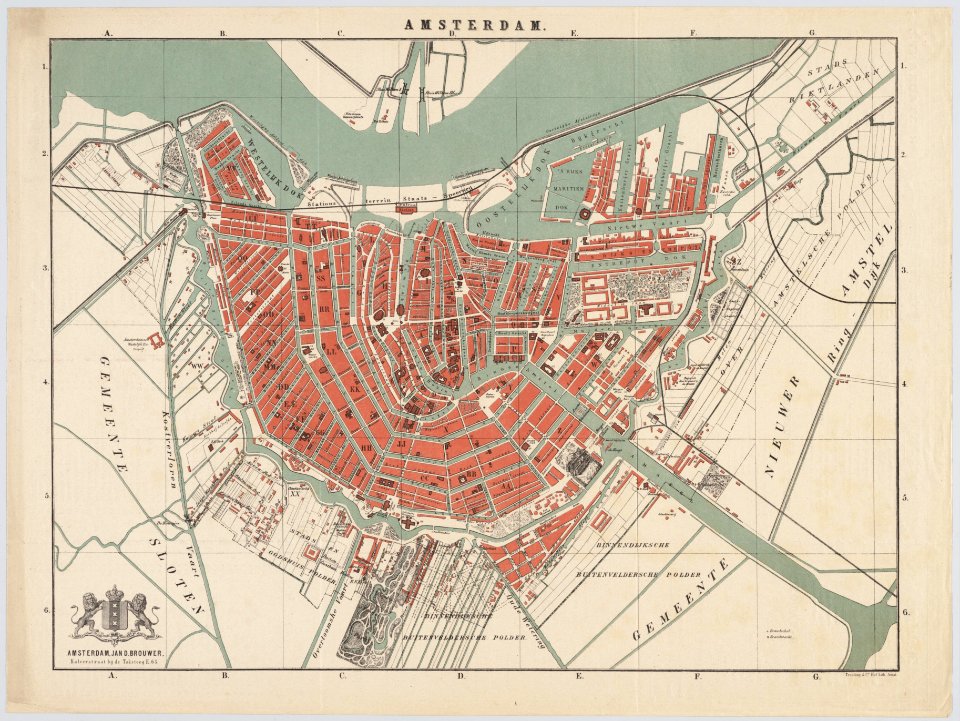
jan d. brouwer
copper engraving print
maps from university of amsterdam special collections
atlas der neederlanden
atlas van der hagen (volume 4)
atlas van der hagen
dutch baroque architecture
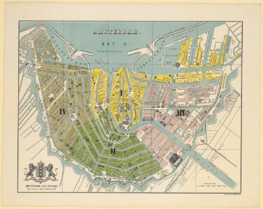
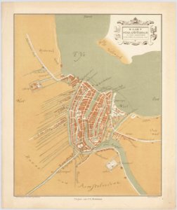
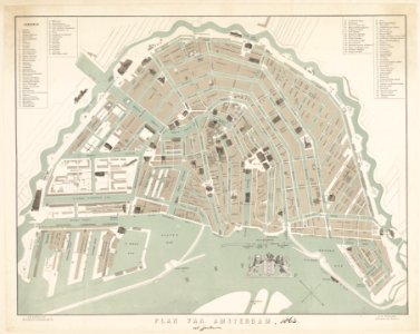
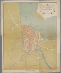
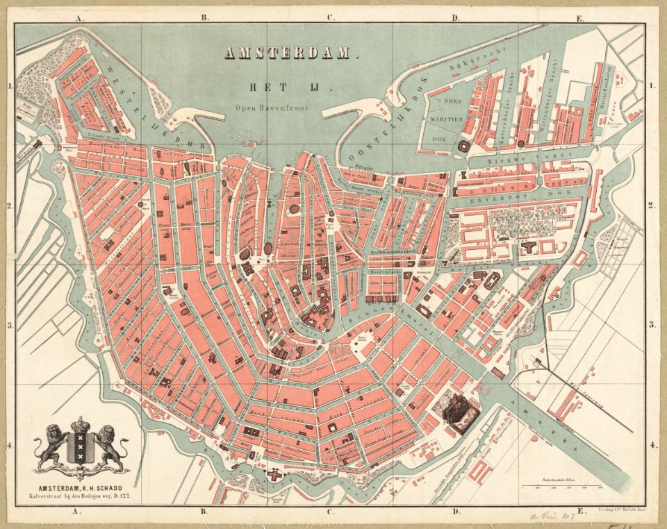
old maps of amsterdam
hendrik van langren map of south asia
1590s maps of iran
nicolaas samuel crucquius
old maps of delfland
hendrik van langren map of south asia
renaissance
hendrik van langren map of south asia
1590s maps of the levant
maps from university of amsterdam special collections
atlas der neederlanden
maps of the caribbean by mercator-hondius
details of old maps
maps of paris from the david rumsey historical map collection
maps of paris by caspar merian
atlas van der hagen (volume 2)
1680s maps of the netherlands
history of university of amsterdam
old maps of amsterdam
maps from university of amsterdam special collections
atlas der neederlanden
colonial history of the united states
old maps of new york (state)
maps of moers by johannes mercator
old maps of duisburg
old maps of haarlem
museum haarlem
maps from university of amsterdam special collections
caartboeck van voorne, 1701
gommarus wouters
cornelis meijer
woodcuts by cornelis anthonisz. in the rijksmuseum amsterdam
jan ewoutsz.
17th-century maps of africa
maps from gallica
maps from university of amsterdam special collections
atlas der neederlanden
maps of paris from the david rumsey historical map collection
maps of paris by caspar merian
maps of paris from the david rumsey historical map collection
maps of paris by caspar merian
house of arenberg
parks in belgium
maps by willem and johannes blaeu
maps made in the 17th century
dutch 17th-century prints in the rijksmuseum amsterdam
maps by daniel stoopendaal
maps by willem and johannes blaeu
maps made in the 17th century
maps by gerardus mercator
kempen (region)
maps from university of amsterdam special collections
atlas der neederlanden
maps from university of amsterdam special collections
atlas der neederlanden
maps from university of amsterdam special collections
atlas der neederlanden
maps of paris from the david rumsey historical map collection
maps of paris by caspar merian
anthonisz., cornelis - gezicht op amsterdam in vogelvlucht - amsterdam museum
oil on panel
maps in the amsterdam museum
1690s maps of palestine
atlas van der hagen (volume 3)
atlas van der hagen
dutch 17th-century prints in the rijksmuseum amsterdam
maps by daniel stoopendaal
old maps of bordelais
maps of médoc
maps by pieter mortier
old maps of genoa
old maps of trinidad and tobago
17th-century maps of venezuela
novus atlas sinensis
old maps of shanxi
old maps of the shetland islands
old maps of the orkney islands
maps from university of amsterdam special collections
atlas der neederlanden
atlas van der hagen (volume 4)
atlas van der hagen
old maps of guizhou
maps from gallica
haarlem nautz map 1822-1829
old maps of haarlem
media from regionaal archief alkmaar
old maps of north holland
alessandro baratta
old maps of genoa
drawings in the stadsarchief amsterdam
johan martinus anthon rieke
maps by willem and johannes blaeu
maps made in the 17th century
historical
history
historical
history
historical
history
historical
history
maps by gerard valck
atlas beudeker
maps by willem and johannes blaeu
maps made in the 17th century
prints of cartouches in the rijksmuseum amsterdam
maps in the rijksmuseum amsterdam
cartouches by willem and johannes blaeu
maps made in the 17th century
maps by willem and johannes blaeu
maps made in the 17th century
historical
history
historical
history
old maps of périgueux
1660s maps of france
old maps of austria
1695 books
maps of haarlemmerhout
old maps of haarlem
frans hogenberg
spanish armada
historical
history
historical
history
historical
history
maps by nicolaes visscher i
atlas van der hagen
historical
history
old maps of the bay of gibraltar
carolus allard
old maps of the dutch gold coast
1818 maps
maps of the firth of forth
old maps of fife
atlas van der hagen (volume 3)
atlas van der hagen
maps of africa in the robert c. williams paper museum
1665 maps of africa
historical
history
old maps of haarlem
museum haarlem
old maps of the western hemisphere
jacob van meurs
atlas van der hagen (volume 4)
atlas van der hagen
maps in the rijksmuseum amsterdam
old maps of franeker
atlas of the great elector
archipelagus orientalis
drawings by jan toorop in the rijksmuseum amsterdam
expressionism,symbolism,pointillism
old maps of auvergne
1660s maps of france
robert gordon of straloch
old maps of sutherland
maps in the rijksmuseum amsterdam
published by frans buffa & zonen
historical
history
historical
history
historical
history
1750s maps of saxony
old maps of leipzig
maps in the rijksmuseum amsterdam
hendrik de leth
maps of goa by linschoten
baroque
maps in the rijksmuseum amsterdam
maps by willem and johannes blaeu
le neptune francois
charles pène 8th
maps from gallica
old maps of rome
maps in the rijksmuseum amsterdam
old maps of tholen
renaissance
1578
map of maastricht by willem and johannes blaeu (1649)
markt (maastricht)
old maps of spitsbergen
1642
prints of cartouches in the rijksmuseum amsterdam
maps in the rijksmuseum amsterdam
maps by jakob van der schley
old maps of southeast asia
maps in the rijksmuseum amsterdam
old maps of franeker
cartouches by willem and johannes blaeu
maps made in the 17th century
201 - 300 of 636
Next page
/ 7


![Special map of a part of Dutch Brabant, Guelders and Cleves or the surroundings of Grave, Ravestein, Helmont, Nijmegen, Fort de Schenk, Cleves, Gennip, Emmerick &c. / I. Condet f. 1748, Johannes Condet, [1748]](https://cdn.creazilla.com/illustrations/10000963180/special-map-of-a-part-of-dutch-brabant-guelders-and-cleves-or-the-surroundings-of-grave-ravestein-helmont-nijmegen-fort-de-schenk-cleves-gennip-emmerick-c-i-condet-f-1748-johannes-condet-1748-md.jpg)


![Map of the craftsmanship of the Old and New Streuyt / A. Steyaart invenit; I. Stemmer's sculpsit; I. Shutters fecit cum aqua forti, Romeyn de Hooghe, [1701]](https://cdn.creazilla.com/illustrations/10000536041/map-of-the-craftsmanship-of-the-old-and-new-streuyt-a-steyaart-invenit-i-stemmers-sculpsit-i-shutters-fecit-cum-aqua-forti-romeyn-de-hooghe-1701-md.jpg)


![Caarte vande polder van Rugge A° 1696 / Heyman van Dyck fecit; A. Steyaart invenit; I. Stemmers sculpsit; I. Luiken fecit cum aqua forti, Romeyn de Hooghe, [1701]](https://cdn.creazilla.com/illustrations/10001404604/caarte-vande-polder-van-rugge-a-1696-heyman-van-dyck-fecit-a-steyaart-invenit-i-stemmers-sculpsit-i-luiken-fecit-cum-aqua-forti-romeyn-de-hooghe-1701-sm.jpg)


![The High Council of Delflant / according to order by Kruikius; [mapped by N. and J. Kruikius]; L. van Anse, T. Doesburch, Jac. et Joan. Deur, and P. Ruyter sculpt, 1712](https://cdn.creazilla.com/illustrations/10001543120/the-high-council-of-delflant-according-to-order-by-kruikius-mapped-by-n-and-j-kruikius-l-van-anse-t-doesburch-jac-et-joan-deur-and-p-ruyter-sculpt-1712-sm.webp)


![Map of the polders of Old and New Roc-anje / A. Steyaart invenit; Heyman van Dyck fecit; I. Stemmer's sculpsit; I. Shutters fecit cum aqua forti, Romeyn de Hooghe, [1701]](https://cdn.creazilla.com/illustrations/10000510590/map-of-the-polders-of-old-and-new-roc-anje-a-steyaart-invenit-heyman-van-dyck-fecit-i-stemmers-sculpsit-i-shutters-fecit-cum-aqua-forti-romeyn-de-hooghe-1701-md.jpg)
![Map of the old new lands in West Voorn / I. Luiken fecit cum aqua forti; A. Steyaart invented; I. Stemmer's sculpsit, Romeyn de Hooghe, [1701]](https://cdn.creazilla.com/illustrations/10000299995/map-of-the-old-new-lands-in-west-voorn-i-luiken-fecit-cum-aqua-forti-a-steyaart-invented-i-stemmers-sculpsit-romeyn-de-hooghe-1701-md.jpg)
![Map of the Old Land of Diepen Dorst / I. Shutters fecit cum aqua forti; A. Steyaart invenit; I. Stemmers sculpt, Romeyn de Hooghe, [1701]](https://cdn.creazilla.com/illustrations/10001043124/map-of-the-old-land-of-diepen-dorst-i-shutters-fecit-cum-aqua-forti-a-steyaart-invenit-i-stemmers-sculpt-romeyn-de-hooghe-1701-md.jpg)


![Stadsprofiel van] ROMA, 1704](https://cdn.creazilla.com/illustrations/10000357441/stadsprofiel-van-roma-1704-md.jpeg)

![Map of Bourdelois, the country of Medoc, and the provostship of Born / [Blaeu], 1635](https://cdn.creazilla.com/illustrations/10001341609/map-of-bourdelois-the-country-of-medoc-and-the-provostship-of-born-blaeu-1635-sm.webp)


![Map of the polder of the old Oost dyck in West Voorn / A. Steyaart invenit; I. Stemmer's sculpsit; I. Shutters fecit cum aqua forti; H. van Dyck fecit, Romeyn de Hooghe, [1701]](https://cdn.creazilla.com/illustrations/10000341870/map-of-the-polder-of-the-old-oost-dyck-in-west-voorn-a-steyaart-invenit-i-stemmers-sculpsit-i-shutters-fecit-cum-aqua-forti-h-van-dyck-fecit-romeyn-de-hooghe-1701-md.jpg)

![Queicheu imperii sinarum provincia decimaquarta / [tirée du P. Martini]; Exc. I. Blaeu, 1655](https://cdn.creazilla.com/illustrations/10001381799/queicheu-imperii-sinarum-provincia-decimaquarta-tire-du-p-martini-exc-i-blaeu-1655-sm.webp)


![Stadsprofiel van] NAPOLI, 1704](https://cdn.creazilla.com/illustrations/10000682766/stadsprofiel-van-napoli-1704-md.jpeg)